|
ATTRACTION SOUTHERN ETHIOPIA
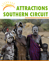 |
The Lower Omo valley is home to a remarkable mix of small, contrasting ethnic groups not only the Bume and Konso, but also the Gelebe, the Bodi, the Mursi, the Surma, the Arbore, and the Hamer, to name but a few.
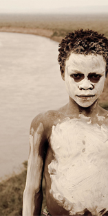
Lifestyles are as varied as the tribes themselves. Lacking any material, culture and artifacts common to other cultures, these tribes find unique ways in which to express their artistic impulses. Both the Mursi and the Karo, for example, are experts at body painting, using clays and locally available vegetable pigments to trace fantastic patterns on each other's faces, chests, arms, and legs. These designs are created purely for fun and aesthetic effect, each artist vying to outdo his fellows. |
| |
THE SOUTHERN TRIBES |
 |
The Omo Valley is virtually free of human habitation but it is rich in palaeo-anthropological remains. According to research conducted by the University of California at Berkeley, hominid remains from the Omo Valley probably date back more than four million years.
Much of Africa's volcanic activity is concentrated along the immense 5,000 kilometers crack in the earth's surface known as the Rift Valley. It is the result of two roughly parallel faults, between which, in distant geological time, the crust was weakened and the land subsided. The valley walls 97 daunting blue-grey ridges of volcanic basalt and granite - rise sheer on either side to towering heights of 4,000 meters. The valley floor 50 kilometers or more across encompasses some of the world's last true wildernesses. Ethiopia is often referred to as the water tower of Eastern Africa because of the many rivers that pour off its high tableland, and a visit to this part of the Rift Valley, studded with lakes, volcanoes and savannah grassland, offers the visitor a true safari experience.
The Omo River tumbles its 350 kilometers way through a steep inaccessible valley before slowing its pace as it nears the lowlands and then meanders through flat, semi-desert bush, eventually running into Lake Turkana. Since 1973, the river has proved a major attraction for white-water rafters. The season for rafting is between September and October when the river is still high from the June to September rains but the weather is drier.
The river passes varied scenery including an open gallery forest of tamarinds and figs, alive with Columbus monkeys. Under the canopy along the riverbanks may be seen many colorful birds. Goliath herons, blue-breasted kingfishers, white-cheeked turacos. Emerald spotted wood doves and red-fronted bee-eaters are all rewarding sights, while monitor lizards maybe glimpsed scuttling into the undergrowth. Beyond the forest, hippos graze on the savannah slopes against the mountain walls, and waterbuck, bushbuck and Abyssinian ground hornbills are sometimes to be seen.
|
| |
THE SOUTHERN TRIBES |
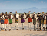 |
The Southern region is comprised of hundreds of ethnic groups. South of Konso and Yabello are inhabited by the Konso people. Except for trading with the neighbouring Borena for salt or cowry shells, outside influence had, until recently, virtually passed by the Konso. The cornerstone of Konso culture, however, is a highly specialized and successful agricultural economy that, through terracing buttressed with stone; enable them to extract a productive living from the none-too-fertile hills and valleys that surround them. |
| |
NECHISAR NATIONAL PARK |
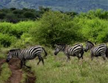 |
Covering 514 square kilometers (319 square miles), Nechisar National Park is situated near the town of Arba Minch, 510 kilometers from Addis Ababa. Lakes Abaya and Chamo are the twin rift valley lakes separated by a neck of land better known as a "Bridge of Heaven". They are the integral part of the park. The park is home to Burch ell’s Zebra, Grant's gazelle, greater Kudu and others. Various species of birds and crocodiles reflect the park's different habitat.
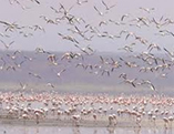
The 188 bird species - including two endemic of the area are quite varied, reflecting the different habitats within the park. Both the red-billed and the gray hornbill are common here, and the Abyssinian ground hornbill is also seen. Also common are fish eagle, king fisher’s, and rollers. Various bustard species are found in the park including the large and impressive Kori. |
| |
MAGO NATIONAL PARK |
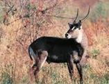 |
Covering an area of 2,162 square kilometers on the banks of Omo River, the Mago National Park is relatively undeveloped for tourists. The broad grasslands teem with herds of Buffalo, Giraffe, Elephant and Kudu, while sometimes it is possible to find Lion, Leopard and Burchell's Zebra.
The park rises in the north to mount Mago (2,528 meters) and is home to 56 species of mammals. Mago National Park mainly grass savannah, with some forested areas around the rivers. Very dense bush makes for difficult game viewing. The Birds are typical of the dry grassland habitat, featuring bustards, hornbills, weavers, and starlings. Kingfishers and herons can be seen around the Neri River, which provides an alternative habitat. |
| |
ABIJATTA - SHALLA LAKE NATIONAL PARK |
 |
Using Lake Langano as your base, it is an easy side trip to visit Abijatta-Shalla Lakes National Park, which is 887 square kilometers (550 square miles) in size, 482 (300) of these being water.
The altitude of the park ranges from 1,540 to 2,075 meters (5,051 to 6,806 feet), the highest peak being Mount Fke, situated between the two lakes. The temperature ranges from 45°C (113°F) at maximum and 5°C (41°F) at minimum. Rain falls between March and April and June and September, averaging 500 mm (19.5 inches). The surrounding area is mainly acacia woodland. Abijatta and Shalla are both terminal lakes but very different in nature. Lake Abijatta is 14 meters (46 feet) deep as opposed to Lake Shalla which is 260 meters (853 feet) deep. |
| |
|
| |
|
|